Help
Making Google Maps for your website or page has traditionally been a complete pain. This tool takes that pain away.
This page should help you with all you need to know about EZ Map and its options.
Settings
If you are signed in to your account, you can give your map a title so you can find it again in your dashboard.
Users of the Google Map API are supposed to use their own API key. This is a series of numbers and letters that identifies the map as belonging to you. If you have an API key you can also restrict the use of your maps to only your own domain(s). You can get an API key at this page.
This is just the ID of the element you want your map to appear in. It's produced in the code given so unless you have another element on your page with the same ID you don't probably need to change this.
This is the width and height of your map in pixels. If you want your map to be as wide as whatever bit of the page you put it in, select the "Responsive Width" option. If you choose the responsive option your map will remain centered if the visitor re-sizes the page.
These numbers are the center point of your map. If you know the latitude and longitude you want to center your map at you can fill this in. Otherwise, just drag the map around and these numbers will update to match the current center position.
The Map Type Control is the control in the top-left of a map that determines the basic look of the map. You can use the selector to choose whether to display this control as buttons or as a dropdown.
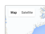
This is the type of map that's shown in the "Map Type" control on the map itself. You can choose to have one of the following map types:
- Road Map
- Road Map With Terrain
- Satellite
- Satellite With Labels
You can use this option to change the type of map shown to visitors, especially handy if removing the control from the map itself.
This sets how zoomed in on the map you are when it loads. Any whole number between 0 (zoomed right out) and around 21, depending on the particular map position can be used here. This reacts to the current map zoom too so if you don't know how zoomed in you want, just zoom the map itself an this field will update for you.
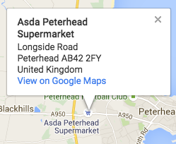
Here you can add markers (pins) to your map. The sequence to add a marker is:
-
Click the
OR
button
-
If you chose to drop a marker, click on the map roughly where you want the pin to go.
If you chose to add a marker by address, enter the adddress or postcode etc into the box that appears, and click
-
-
If you don't want the marker to have an information window when someone clicks the marker click
-
Otherwise, fill in any fields in the form that appear that you want (keep it short-ish). Anything not filled in won't be used and each individual element gets it's own class so you can style these to suit the page you'll be putting the finished map if you want. When you're happy with the details click
-
-
Your pin will now be on the map. You can click it to see how any info window looks and drag it around to reposition it if it was a bit off.
For each marker you create you'll see some more options. You can do the following operations on a marker.
-
Marker Title — Just type it's new name in the space and it'll be automatically updated. (The title shows when you hover on a marker on the map)
-
Change Icon — If you click this button you'll be presented with an overlay containing a number of different icons you can use for your marker. If you are logged in, you can also save your own icon, which will be available to just select for all your maps. Just click on an icon to use it for that marker.
-
Center Here — Clicking this button will center the map on that marker's position. If you resize the map or move it around you may need to click this button again to re-center it here before copying your code.
-
Finally you can delete the individual marker altogether by clicking this button for that marker.
-
When you have two or more markers on your map, a "Marker Clustering" toggle appears in the Markers section. Enabling this groups nearby markers into numbered clusters at lower zoom levels, making dense maps much easier to read.
Clusters automatically split apart as users zoom in, revealing individual markers. The cluster icon displays the number of markers it contains.
You can use this toggle to remove the map type control from the map altogether.
This is a small button on the top-right of the map that allows a person to make the map full-screen on their device.
Shows or hides the streetview option on the bottom-right of the map.
The zoom control is the plus and minus on the bottom right of a map. Deselecting this option will remove those buttons from the map. Zooming will still be available by way of the other zoom options (Keyboard Controls, Doubleclick Zoom and Scrollwheel Zoom) unless these are also turned off.
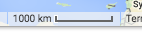
This is a small part on the bottom of the map showing the scale of the map at the current zoom level for that area, clicking it changes the scale from metric to imperial units.
If this is deselected the person will not be able to drag the map around.
You can double-click your mouse on the map to zoom in (and hold ctrl and double-click to zoom out). Deselecting this option stops this functionality on your map.
You can use the scroll function of your mouse to zoom in and out of a map. Turning off this option stops this functionality.
You can control Google Maps navigation by using the keyboard. Deselecting this option disables that functionality on your map.
At some zoom levels some local attractions or places of interest will show up. These have little information windows attached to them by default that will show up when you click on the place. Deselecting this stops these places from being clickable on your map. Of course you can still place a marker anywhere you want an information window to appear.
Shows or hides the rotate control. This control only appears when 45° oblique imagery is available for the current location and zoom level.
Shows or hides the camera control — a compass-style control that provides both zoom and pan functionality. This is a separate control from the zoom-only buttons.
When a control is enabled, you can choose where it appears on the map. The default position varies by control. Available positions include Top Left, Top Center, Top Right, Left Center, Right Center, Bottom Left, Bottom Center, and Bottom Right.
Data layers overlay real-time information from Google onto your map. These are simple toggles — no additional configuration required.
Overlays real-time traffic conditions on roads, displayed as colour-coded lines (green for clear, yellow for moderate, red for heavy traffic).
Shows public transport routes and stations, including bus, rail, and ferry lines.
Displays dedicated bike paths, recommended cycling routes, and other bike-friendly roads.
Controls how the map responds to touch and scroll gestures.
- Auto (default) — the map chooses the best behavior based on context.
- Cooperative — requires two-finger scroll to zoom the map; single-finger scrolls the page. Recommended for maps embedded in content-heavy pages.
- Greedy — the map captures all touch/scroll gestures.
- None — disables all gestures entirely.
These options are found under the Advanced accordion in the settings panel. Most users won't need to change them.
Scales the default map UI controls (zoom buttons, etc.) in pixels. Leave at 0 for the Google Maps default size.
Restricts the zoom range of the map. Useful for preventing users from zooming too far in or out.
Sets the compass heading of the map in degrees (0–360). 0 is north, 90 is east, etc.
Sets the viewing angle. 0° is straight down, 45° provides an oblique perspective (only available at zoom 18+ in supported areas).
The colour shown behind map tiles while they load. Only visible briefly during panning or on slow connections.
Locks the map to a specific geographic area. Users cannot pan or zoom outside the defined bounds. Use the "Use current viewport" button to quickly set the bounds to whatever area is currently visible on the map. Enable "Strict Bounds" to prevent zooming out beyond the restricted area.
Import external geographic data onto your map using KML or GeoJSON files. These options are found under the Advanced accordion in the settings panel.
Enter the public URL to a KML or KMZ file. The file must be publicly accessible — Google's servers fetch it directly. KML files can contain points, lines, polygons, and other geographic data created in tools like Google Earth.
Enter the URL to a GeoJSON file. The file must be CORS-enabled or hosted on the same domain as your map. GeoJSON is a standard format for encoding geographic data structures and is widely supported by mapping tools.
Customise the appearance of the map container element itself.
Rounds the corners of the map container in pixels. Set to 0 for square corners.
Adds a CSS border around the map container. Use standard CSS border syntax, e.g. "2px solid #333" or "1px dashed red".
You can click this button to save your map to your account. It'll then be available for you to re-visit and edit.
If you are working on a saved map you will also have these buttons
Cloning a map means making an exact copy of the map and saving it as a new map. This can be useful if you've set up a map to be your base map setup that you use to make your other maps from. Just clone the base and work from there.
Getting a static image is a way to save your map as a non-interactive image, perhaps for use in a piece of print work or some other image use.
Export your map data as a KML file, which can be imported into Google Earth, Google My Maps, or other mapping applications.
Export your map data as a compressed KMZ file, which is a zipped KML file that can be imported into Google Earth and other mapping applications.
Deleting a map simply removes all records of the map from your account. Any marker icons saved during this maps's creation are not removed from your account so you can use them again in future maps.
The brilliant people at Snazzy Maps have made their theme repository available to me for you to use on your maps. There are currently 190 Themes.
If you want to try a theme on your map just click the preview icon for it and your map will be instantly updated.
You can click this button near your map preview if you want to remove a theme and go back to the Google Map defaults. This button only appears if you have a currently applied theme.
If you have a Google Cloud Console account, you can use Google's cloud-based map styling to apply custom styles to your maps. This is an advanced feature for users who want more control than Snazzy Maps themes provide.
- Open the Google Cloud Console styles page, then create or edit a map style in the Style Editor. You can design both light and dark mode versions.
- Create a Map ID in the Cloud Console and associate your style to it.
- Paste the Map ID (not the Style ID) into the Cloud Styling section in EZ Map.
- Choose a Color Scheme: Follow System (auto light/dark based on your visitor's device), Light only, or Dark only.
For full documentation, see Google's Cloud-based Map Styling guide.
Zoom in on the map then click this button and position your marker on the location you want.
Now click the center here button next to your marker. The Latitude and Longitude boxes will now be filled with the coordinates of your place.
If you've put the wrong URL in the box so you're getting a broken image indicator rather than the image you wanted for your marker, follow these steps
- Click this button for the marker, then find your broken icon in the list.
- Click this button under the broken image indicator to delete it.
If you think you might have found a bug, please fill in this form:
Snazzy Maps have a brilliant wizard style tool to make designing your own themes simple.
You can add the following rules to your CSS. (If you are not using the automatic update code you'll see this in your code output)
<style>
  #ez-map .infoTitle{}
  #ez-map .infoWebsite{}
  #ez-map .infoEmail{}
  #ez-map .infoTelephone{}
  #ez-map .infoDescription{}
</style>
…this is where you can style your elements to suit your page. If you do nothing they'll take on your default styling for the type of element they are:
infoTitle: h3infoWebsite: span (contains an 'a' element)infoEmail: span (contains an 'a' element)infoTelephone: spaninfoDescription: p